Howe Green - Great Mascalls Farm - Galleywood - Stock - Ramsden Heath
- Downham - South Hanningfield - East Hanningfield - Howe Green Circular
4th April 2022
| Distance |
Time |
Elevation in meters |
Km |
Elapsed
Hrs-Mins |
Moving
Hrs-Mins |
Gain |
Loss |
Min |
Max |
| 32.6 |
8H18 |
6H52 |
312 |
312 |
21 |
98 |
|
|
|
|
|
|
|


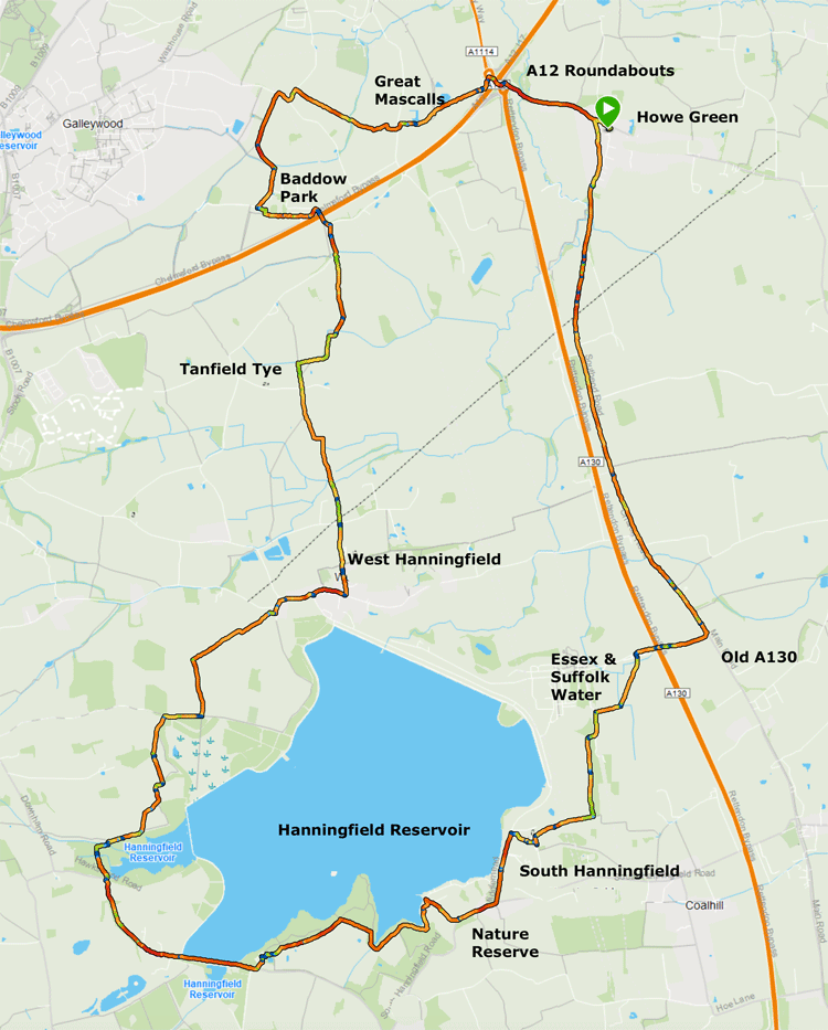
We squeezed this walk into our busy diaries without any concern re the weather; as it happened the first part of the day was wet and windy and we wore rain gear and had rucksack covers on. Still we were in good spirits as we left Howe Green for the 30km walk. Due to the rain I did not take as many photos as I normally do, but I have built up a picture by using photos from earlier walks when the weather was better.
We took the normal route to Galleywood; Down to the roundabouts at Junction 17 on the A12, the tricky crossing of the roundabouts and up the slip road to the stile; Up to Great Mascalls Farm: Across two fields on the Chelmsford Centenary Path to Vicarage Lane; left and right and into The Chase; Through the vineyard and on to Galleywood; Left towards Stock over the bridge on the A12 and on to Bakers Lane. |


Down Gingerbread Hill to the A12

A12 roundabouts


Approaching Great Mascalls Farm

Picking up the Chelmsford Centenary path opposite Great Mascalls Farm


The field leading to Vicarage Road. The rape seed has grown a lot since
I was last here and it was WET! This is one of a few photos that I took on the day.

New house opposite The Chase


Jubilee Copse

Crossing the A12

The A12

Between the A12 bridge and Bakers Lane

Coming onto Bakers Lane; I usually turn left here but for this walk we went to the right.

Into the mobile home park


The path continues in the right hand corner of the large car park and is easy to miss

The path runs along the fence of the huge Jehovah's Witnesses HQ


At this point you head to the line of conifers shown below. You can go straight ahead here, which is where the footpath is shown on the OS map, but this involves walking for a long way across the ploughed field. The best thing to do is to turn right (but not along the fence line) for 200m and then cut across the ploughed field diagonally to the tree line. This is just before a line of telegraph poles.
To the left of the conifer hedge shown below is West Hanningfield Hall, which is on Hall Road. |

The path runs alongside this line of trees, and comes out in Hall Lane. Here you
turn right towards Ship Road.

West Hanningfield Hall, to the right of the conifer tree line.

Having turned right along Hall lane from West Hanningfield Hall, you come to the
T-junction with Ship Lane. West Hanningfield is to the left here, but the footpath
we took starts about 30 meters to the right along Ship Lane.

The path across the field off Ship Lane


At the end of this section, the path to the right goes to Stock; for our walk
we carried straight on.

This section leads to Lower Stock Road


On reaching Lower Stock Road, we turned left for about 300 meters

The path goes off to the right


At this point there is a dog-leg as the path goes to the left of the hedge


The path comes out on to Downham Road where you turn left. Here you have to walk
for about 300m along quite a busy road until you reach Seamans Lane oh the left
(On St Peter's Way) and a snicket on the right. We went right towards Stock. |

Seamans Lane on the left, which takes you back to West Hanningfield

The snicket opposite Seamans Lane. This leads on to Mill Road where you turn
right towards Stock

| After 500 meters you turn left down Furze Lane, and then left towards Ramsden Back Common. Here the road swings to the left but you carry on straight, down Mill Lane Bridleway. At the end of Mill Lane where the road meets the Downham Road there are two alternatives. First up, is to turn right and go as far as the Nags Head pub, then crossing a style to take the route via fields joining Park Lane in Ramsden Heath. If, however, there has been a lot of rain and the fields are muddy, an alternative is to turn left and go a few hundred yards along Downham Road to where it joins Park Lane. Turning right here takes you along a pavement, past houses, until you come to the same point as the field route in Ramsden Heath. |

Turning right off Downham Road along Park Lane to Ramsden Heath

De Beauvoir Lodge

De Beauvoir House
To the left of De Beauvoir House is a five-bar gate with a stile tucked away to the left.
This is the start of the route to Downham Village

The five-bar gate to the right of De Beauvoir Lodge and the left of De Beauvoir House

The stile tucked in to the left of the five-bar gate

You soon come to outbuildings; the path is to the left and through the five-bar
gate just visible in the background

The route rises along a concrete path towards the trees

At the end of the concrete path, the route goes through a gate and turns right

There is not much of a path at first and you begin to wonder if you have come the right way!

Right, up the side of the field

Conveniently placed bench for a break. The views from this point are quite extensive

The path comes out on School Road opposite a large house "High Meadows"

Turn left, along the pavement

As you approach the pub, there is a path on the right hand side


The path passes to the left of a fence made of green metal roofing sheets before reaching
Hawkswood Road. From here you can enter the Hanningfield Nature Reserve and
work you way to the Fishing Lodge.


The Fishing Lodge


Leaving Hanningfield Reservoir and entering South Hanningfield

The Old Windmill

Down Middlemead

Turn right towards the Church


Immediately behind the church is the beautiful thatched house "Bifrons"; whilst it looks as
though this is the natural way to go, I wanted the path at the rear of the church
which goes off in the direction of the Essex & Suffolk Water HQ.

The route I had intended from here was as described in my 7th February 2022
walk of 22.22 km
| However we made a slight error and did not head towards the Essex & Suffolk Water HQ, and took a route that led to Rettendon Crossroads. A deviation we were not expecting, but nevertheless we learnt more about the paths around South Hanningfield and Rettendon. |

| After reaching the point where St Peter's Wayt crosses Back Lane in East Hanningfield, we decided not to take the muddy path whoich goes into the center of the village via the sports field, but continued down back Lane. We took a short link path from Back Lane to East Hanningfield Road, and came back to Howe Green by the normal Great Gibcrack's Chase route. |
|